Tech Specs

In The Box
Manual & Warranty
Do you have an old GPS unit lying around? The GPS Nation Trade In and Up program is a great way to trade in your old and used GPS for credit towards a new GPS. The choice is entirely yours! We’ve made the process simple and streamlined. Follow these simple steps, and you will be on your way to receiving credit towards your brand new GPS!
1. Get a quote
To get your free quote, provide your GPS type, manufacturer, model, and condition. Within 24 hours, you will receive a quote for the trade-in value of your current product. The GPS trade-in/trade-up form is at the bottom of this page.
2. Ship your product(s) for trade
After accepting our offer, pack your product(s) safely and ship them to us using the pre-paid shipping label provided to you. We will provide a confirmation email when your trade-in arrives at our warehouse. You have 30 days from the date you complete your on-line trade to ship the product to GPS Nation.
3. Make your purchase
Once we receive your product at our warehouse and we validate the stated condition, we will send you a confirmation email. If you elect to receive credit towards a new GPS at gpsnation.com, your store credit will be issued, and you are free to make your purchase.
Reviews
Ask a Question
Tech Specs

In The Box
Manual & Warranty
Trade-In Program
Do you have an old GPS unit lying around? The GPS Nation Trade In and Up program is a great way to trade in your old and used GPS for credit towards a new GPS. The choice is entirely yours! We’ve made the process simple and streamlined. Follow these simple steps, and you will be on your way to receiving credit towards your brand new GPS!
1. Get a quote
To get your free quote, provide your GPS type, manufacturer, model, and condition. Within 24 hours, you will receive a quote for the trade-in value of your current product. The GPS trade-in/trade-up form is at the bottom of this page.
2. Ship your product(s) for trade
After accepting our offer, pack your product(s) safely and ship them to us using the pre-paid shipping label provided to you. We will provide a confirmation email when your trade-in arrives at our warehouse. You have 30 days from the date you complete your on-line trade to ship the product to GPS Nation.
3. Make your purchase
Once we receive your product at our warehouse and we validate the stated condition, we will send you a confirmation email. If you elect to receive credit towards a new GPS at gpsnation.com, your store credit will be issued, and you are free to make your purchase.
Overview
Garmin Irish Sea Charts BlueChart g3 | HXEU004R | microSD/SD
Experience unparalleled coastal navigation with the Garmin Irish Sea Charts BlueChart g3. This innovative product offers industry-leading coverage, clarity, and detail, making it an essential tool for mariners and fishing enthusiasts alike.
Key Features:
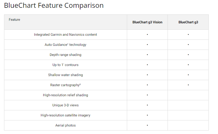
- Comprehensive Coverage: Detailed coastal charts with integrated Garmin and Navionics data ensure that you have the most up-to-date information at your fingertips.
- Auto Guidance Technology: Calculate your route effortlessly with Auto Guidance, which considers your desired depth and overhead clearance for a suggested path overlaid on your chart.
- Depth Range Shading: View your target depth at a glance with high-resolution Depth Range Shading, offering up to 10 depth ranges.
- Detailed Contours: Benefit from 1-foot contours that provide an accurate depiction of the bottom structure, enhancing navigation in swamps, canals, and marinas.
- Shallow Water Shading: Navigate with confidence by utilizing shallow water shading that highlights areas at a user-defined depth to avoid.
- NOAA Raster Cartography: Access paper chart-like views of NOAA-surveyed areas through the ActiveCaptain app, complete with labeled points of interest including longitude and latitude.
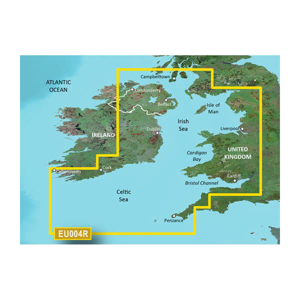
Extensive Coverage Area:
The charts cover a wide range of regions:
- British Coast: From Port Ellen on the Isle of Islay to Falmouth, including the Isle of Man and the Isles of Scilly.
- Iris Coast: From Sheep Haven to Caherciveen, Republic of Ireland, covering Londonderry, The Storks, Belfast, and Dublin.
Upgrade your boating experience with the Garmin Irish Sea Charts BlueChart g3. Whether you're navigating coastal waters or seeking the best fishing spots, this chart system is designed to enhance your journey with precision and clarity.


 Garmin Warranty