Garmin ECHOMAP UHD2 7" sv Chartplotters 74sv with GT54UHD-TM Transducer and Garmin Navionics+ U.S. Coastal & Great Lakes Mapping (010-02685-01)
Garmin ECHOMAP UHD2 7" sv Chartplotters 74sv with GT54UHD-TM Transducer and Garmin Navionics+ U.S. Coastal & Great Lakes Mapping (010-02685-01)
SKU: 010-02685-01
Stock bas
 Afficher tous les détails
 WhatsApp
 SMS - Text us!
 Email Us!
 Help Desk


Avis
Spécifications
Dans la boîte
GT54-TM transducer
Power cable
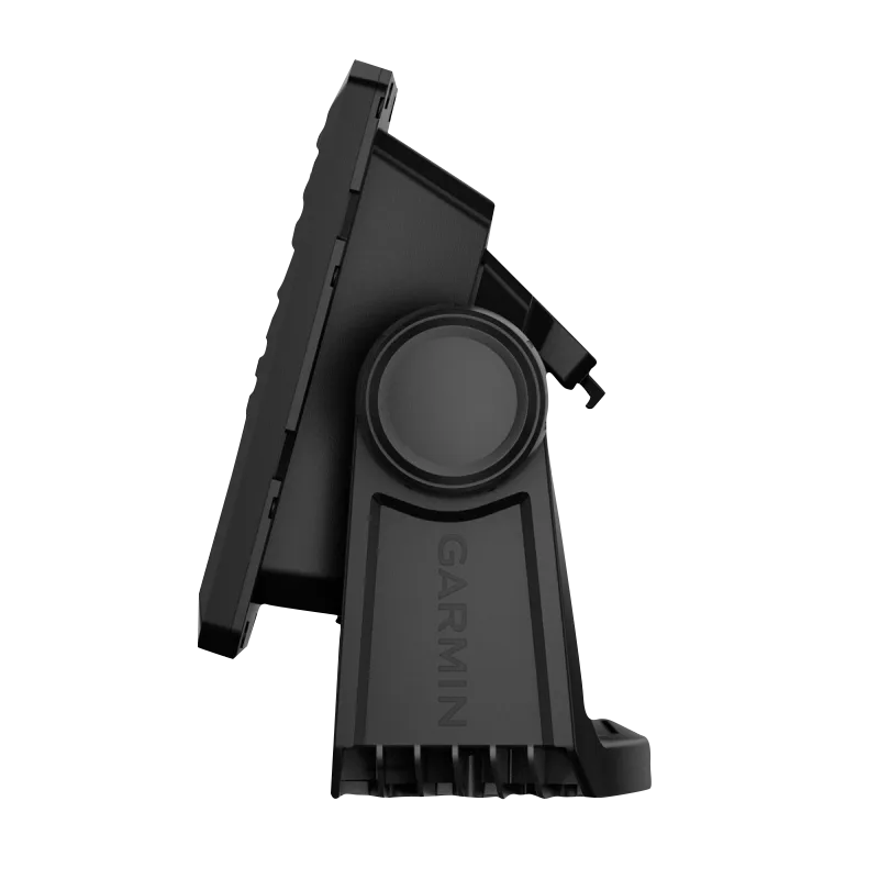
Tilt/swivel mount with quick release cradle
Protective cover
Hardware
Documentation
Manuel et garantie
 Garmin Warranty
Vous avez un vieux GPS qui traîne ? Le programme Trade In and Up de GPS Nation est un excellent moyen d'échanger votre ancien GPS usagé contre un crédit pour l'achat d'un nouveau GPS. Le choix vous appartient entièrement ! Nous avons simplifié et rationalisé le processus. Suivez ces étapes simples et vous serez sur la bonne voie pour recevoir un crédit pour votre tout nouveau GPS !
1. Obtenez un devis
Pour obtenir votre devis gratuit, indiquez le type, le fabricant, le modèle et l'état de votre GPS. Dans les 24 heures, vous recevrez un devis correspondant à la valeur de reprise de votre produit actuel. Le formulaire de reprise/d'échange de GPS se trouve au bas de cette page.
2. Expédiez votre/vos produit(s) pour le commerce
Après avoir accepté notre offre, emballez votre ou vos produits en toute sécurité et expédiez-les-nous à l'aide de l'étiquette d'expédition prépayée qui vous a été fournie. Nous vous enverrons un e-mail de confirmation lorsque votre échange arrivera à notre entrepôt. Vous disposez de 30 jours à compter de la date à laquelle vous avez terminé votre échange en ligne pour expédier le produit à GPS Nation.
3. Effectuez votre achat
Une fois que nous aurons reçu votre produit à notre entrepôt et que nous aurons validé l'état indiqué, nous vous enverrons un e-mail de confirmation. Si vous choisissez de recevoir un crédit pour un nouveau GPS sur gpsnation.com, votre crédit de magasin sera émis et vous serez libre de procéder à votre achat.
Avis
Poser une question
Spécifications
Dans la boîte
GT54-TM transducer
Power cable
Tilt/swivel mount with quick release cradle
Protective cover
Hardware
Documentation
Manuel et garantie
Programme d'échange
Vous avez un vieux GPS qui traîne ? Le programme Trade In and Up de GPS Nation est un excellent moyen d'échanger votre ancien GPS usagé contre un crédit pour l'achat d'un nouveau GPS. Le choix vous appartient entièrement ! Nous avons simplifié et rationalisé le processus. Suivez ces étapes simples et vous serez sur la bonne voie pour recevoir un crédit pour votre tout nouveau GPS !
1. Obtenez un devis
Pour obtenir votre devis gratuit, indiquez le type, le fabricant, le modèle et l'état de votre GPS. Dans les 24 heures, vous recevrez un devis correspondant à la valeur de reprise de votre produit actuel. Le formulaire de reprise/d'échange de GPS se trouve au bas de cette page.
2. Expédiez votre/vos produit(s) pour le commerce
Après avoir accepté notre offre, emballez votre ou vos produits en toute sécurité et expédiez-les-nous à l'aide de l'étiquette d'expédition prépayée qui vous a été fournie. Nous vous enverrons un e-mail de confirmation lorsque votre échange arrivera à notre entrepôt. Vous disposez de 30 jours à compter de la date à laquelle vous avez terminé votre échange en ligne pour expédier le produit à GPS Nation.
3. Effectuez votre achat
Une fois que nous aurons reçu votre produit à notre entrepôt et que nous aurons validé l'état indiqué, nous vous enverrons un e-mail de confirmation. Si vous choisissez de recevoir un crédit pour un nouveau GPS sur gpsnation.com, votre crédit de magasin sera émis et vous serez libre de procéder à votre achat.
Aperçu
Garmin ECHOMAP UHD2 7" sv Chartplotters 74sv with GT54UHD-TM Transducer and Garmin Navionics+ U.S. Coastal & Great Lakes Mapping (010-02685-01)
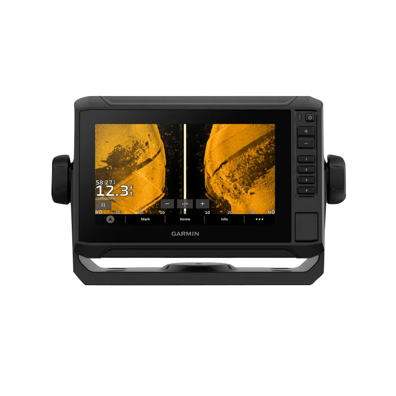
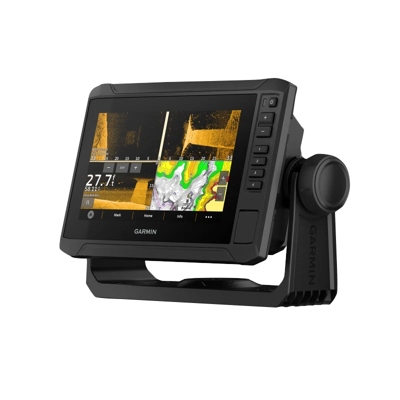
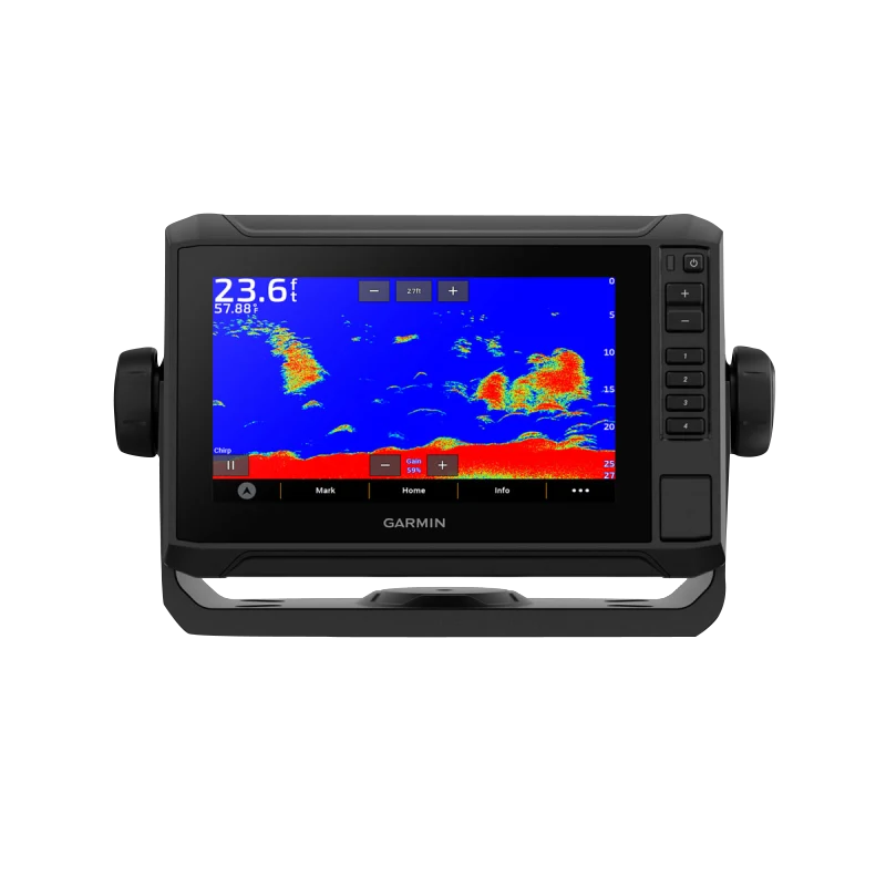
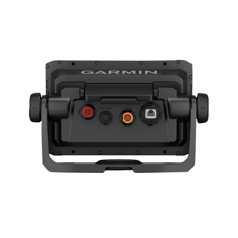
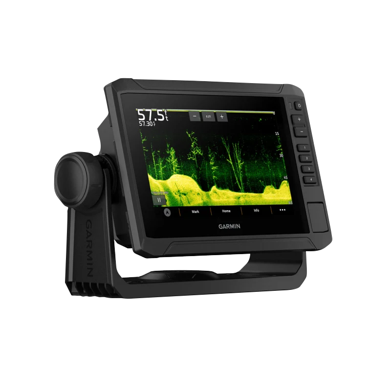
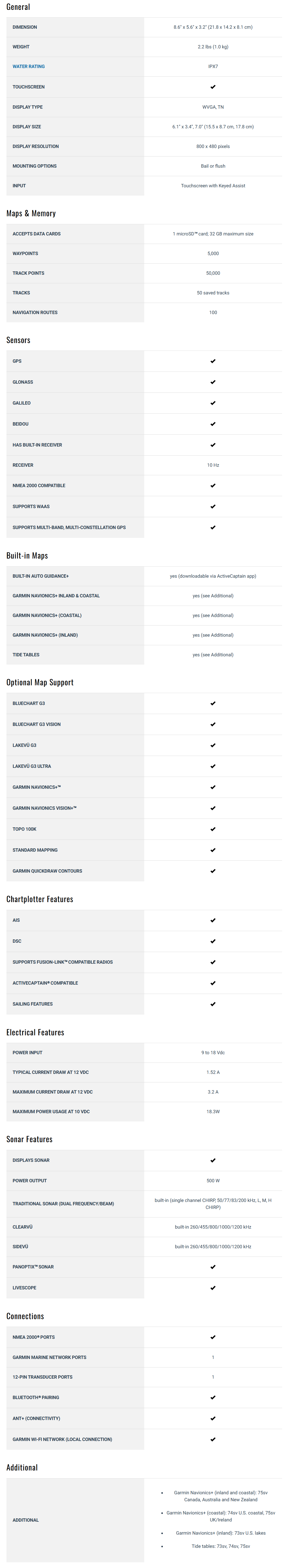
The Garmin ECHOMAP UHD2 7” sv Chartplotter (74sv with GT54UHD-TM Transducer) is a feature-rich, high-performance navigation and sonar system designed for serious anglers. Equipped with a premium touchscreen display, cutting-edge sonar technology, and advanced mapping capabilities, this chartplotter gives you a significant advantage on the water.
Key Features:
- 7” Touchscreen with Keyed-Assist: A bright, user-friendly touchscreen with physical buttons for added convenience and control.
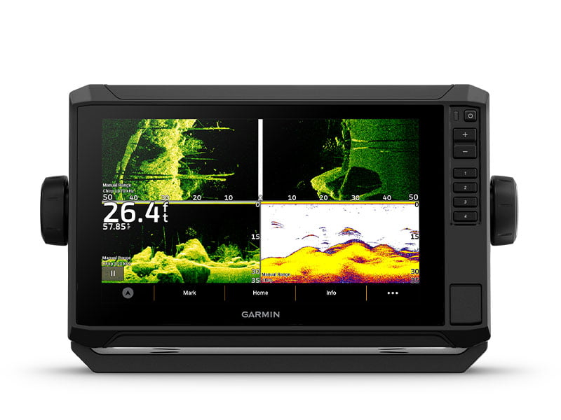
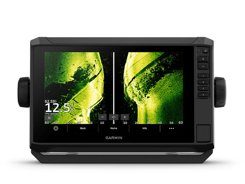
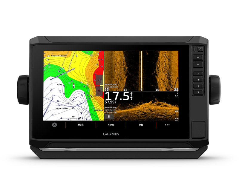
- Triple Sonar Compatibility: Supports Garmin traditional, ClearVü™, and SideVü™ sonar technologies, delivering superior underwater detail.
- GT54UHD-TM Transducer Included: Comes with a GT54UHD-TM transducer, offering Ultra High-Definition sonar imaging for precise fish and structure identification.
- LiveScope™ Sonar Support: Compatible with LiveScope™ real-time scanning sonar, providing unmatched clarity of fish and surroundings.
- Vivid Color Palettes: High-contrast vivid scanning sonar color palettes enhance target visibility for easier identification.
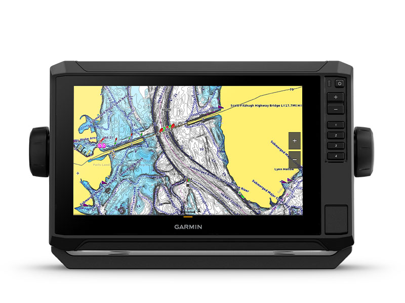
- Preloaded Garmin Navionics+ U.S. Coastal & Great Lakes Mapping: Includes built-in Garmin Navionics+ cartography with a 1-year subscription for daily updates, depth range shading, and more.
- Wireless Networking: Share sonar, waypoints, and routes with other compatible ECHOMAP UHD2 chartplotters on your boat.
- ActiveCaptain® App Integration: Built-in Wi-Fi® connectivity pairs with the ActiveCaptain app, allowing access to OneChart™, smart notifications, software updates, and Garmin Quickdraw™ Community data.
- Auto Guidance+™ Technology: Chartplotters with Garmin Navionics+ charts can download Auto Guidance+ technology for real-time automated route planning via the ActiveCaptain app.
- Force® Trolling Motor Compatibility: Wirelessly connects to Garmin Force trolling motors for easy waypoint navigation, speed control, and boat positioning.
- Power-Pole® Integration: Network with Power-Pole shallow water anchors for smart anchor auto-deployment, jog functions, and enhanced boat control.
- Charge Integration from Power-Pole: Monitor and manage battery power allocation, emergency starts, and energy transfer directly from the chartplotter display.
- Multi-Band GPS: Provides enhanced location accuracy, even in areas with weak or reflected GPS signals.